Laser scanning, GIS, & Parametric modeling Catalog
Project Portfolios and Appendices can be available upon request. Please use the “Contact” Tab to request information to be sent your way.
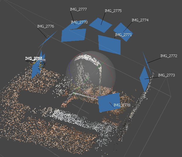
Structure from Motion Photogrammetry Process | Summer 2020
Digital Methods & Applications in historic preservation (HP)
Various platforms were used to achieve the tasks needed to digitize cultural heritage practices in Summer 2020. An external website was created by me to illustrate these digitized practices, coined as the Innovative Preservation website. The platforms used in this process include:
Geographic Information Systems (GIS) with QGIS
Terrestrial Laser Scanning (TLS) with JRC Reconstructor
Structure from Motion (SfM) with Agisoft Metashape
Virtual Reconstruction (VR) with Sketchfab
Sketchfab is the most widely used website platform for making 3D data of historic sites and objects. It is available online, with over 100,000 free and viewable cultural heritage models. The 3D SfM model made was published to Sketchfab, allowing the model to be readily accessible to wider audiences.
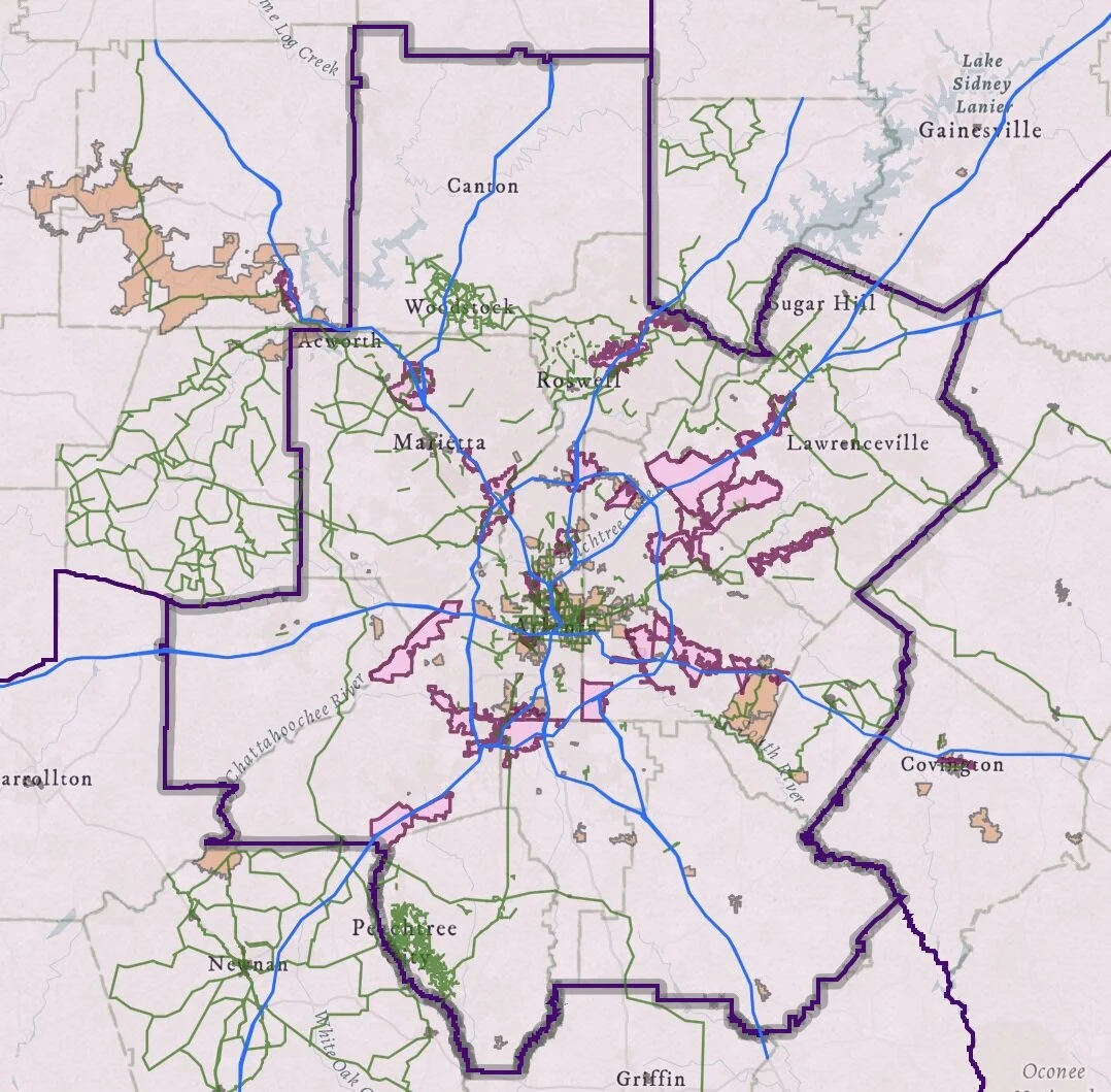
Georgia’s Local and Regional Districting | Summer 2020
Geographic Information Systems (GIS) WebsiteS Using ARCGIS Online
I created and deployed a Story Map using both a Map Series and Public Information Map template to analyze the historical significance of Georgia’s local and regional districting. Georgia, currently comprised of 159 counties, is the second largest county-based state in the nation. The largest county-based state in the nation, Texas, has 254 counties. This analysis aims to address why there are so many counties in Georgia, and what are or what were their purposes. Georgia has a unique political history in the colonial era that pivots, changes, and morphs the region into new governmental structures over the course of just a few decades. After the Revolution, the political and governing strategies helped formulate local and regional planning structures currently in place in Georgia. The intention of introducing these histories is to raise awareness of the existing urban fabrics and structures Georgians now live in, and how its citizens can better-leverage existing infrastructures to stimulate better local and regional economies.

Stitching Atlanta's Urban Fabrics Together | Spring 2020
Geographic Information Systems (GIS) WebsiteS Using ARCGIS Online
I also created and deployed a Story Map using the Journal template to describe, analyze, and present a topic of interest. My topic of interest was analyzing an incorporation of Atlanta’s existing urban fabric networks. I identified existing multi-modal transportation networks within the Atlanta Metropolitan Area (AMA), and how they can be better utilized in future years within Atlanta’s planning procurement process to mitigate future concerns of existing socioeconomic disparities and transit inaccessibility observed. Using interactive interfaces between existing urban fabrics, I developed a website that planners can utilize in their research regarding crash data mitigation, crime rate mitigation, more cohesive project planning and financing within GDOT’s GeoPI database, and new planning strategies for local Community Improvement Districts (CIDs) that can help better model the Atlanta Regional Commission (ARC) travel demand models.

Parametric Sequencing of Kengo Kuma’s Prostho Museum | Fall 2019
Voxel Sequence: An Analysis of Kengo Kuma’s Prostho Museum
This Media and Modeling course introduced me to parametric modeling, design analysis and diagramming through Rhino, Illustrator, and Grasshopper. I was introduced to alternative ways of parametric geometry in Grasshopper through various tutorials and examples that introduced me to different aspects of systems thinking. Working with a group of selected contemporary precedents, I worked with two other students to develop rich and articulate models that are full of detail and aesthetic features. The objective of this project was to choose from contemporary architectural projects that provide various typological features and systems that were studied via diagrams and reconfigured as generative scripts built mainly using Grasshopper tools. Each parametric component of the precedent was used to study the variability of a particular system by analyzing computational geometry, structure, panels, cores, and circulation. My team developed a set of drawings, diagrams and models that digitized our precedent to extract geometric rules and principles. Then, we produced generative scripts to rethink the precedent as a generative parametric system. The acquired knowledge was expanded upon by studying variations to test different massing and structural approaches. We presented our findings as a parametric building that combines multiple systems of structure, slabs, envelope, and core.